I have the details for my first brevet of 2014 up on my Montana Populaire and Brevets Website along with the dates and locations of the rest of our 2014 rides. Click on over and take a look.
I've still got a lot of work to do, as most of the routes need to be mapped and submitted by me, and approved by RUSA before I can post them. I'll be working on this in the next weeks and months. It's a lot of work to get these routes approved, but it's also fun.
I've also got some new permanents I need to post.
Finally, I've taken the plunge and signed up for the Seattle International Randonneurs' Cascade 1200. It starts on June 21, so that means I've got to do a lot of training in the not-so-nice weather months of year. It's going to be a real challenge to be in peak fitness that early.
Stay tuned, and let me know if you have any questions about the upcoming seasons rides, or randonneuring in general.
Tuesday, January 21, 2014
Monday, January 6, 2014
End of the year-Beginning of the year randonneuring in Oregon
Since daughter Stephanie moved to Portland, Oregon in 2009, I've been coming up with creative reasons why I need to go there.
Randonneuring is the perfect excuse.
Randonneurs USA offers awards for accomplishing various feats of randonneuring including the popular P-12 and R-12 awards. The P-12 award is for riding an approved 100-199 kilometer event in 12 consecutive months, and the R-12 award is for riding an approved 200 kilometer or longer event in 12 consecutive months.
Getting the December and January events done in Montana is very difficult given our wintery weather. Last year I went for the P-12 and got my December and January events done by riding two different 100+ kilometer rides out of Portland. For this season, I've decided to go for both the P-12 and the R-12. I got my December P-12 ride done on the 1st of December here at home one day before a big blizzard hit that has left the local roads icy for the duration. So my son Jackson and I, (wife Brenda had to stay home for work) loaded up the bike again and headed for Portland.
The goal this time was to at least get my December 200K done. I contacted fellow Randonneur extraordinaire Lynne Fitzsimmons about doing one of her rides on the last weekend of 2013. Lynne was available so we planned to meet up in Beaverton to ride the Beaverton-Hagg Lake-Carlton 200K Permanent. Lynne wrote a nice detailed report on her blog so please go there and check it out. The following is a photo story of my Oregon riding:
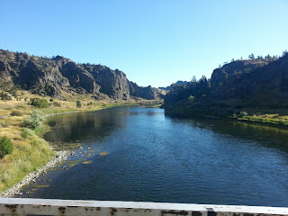
 It was gray and gloomy at Hagg Lake. We did a lap around the lake on a hilly tree covered road. It was beautiful. The bad weather did have one advantage-we had the place almost all to ourselves which I understand wouldn't be the case when it's nice out.
 Lynne and I were joined by Jeff Arasmith of Portland. We stayed together the whole ride (more or less) and rode, chatted, and froze together in peace and harmony. It was an entirely satisfying day. I got my December R-12 out of the way, I felt pretty good on the bike despite not riding outdoors since the first day of December, and I got to see some absolutely beautiful Oregon countryside.
 The ride went right past the Roloff Farm, from the TV show Little People, Big World. Jackson is a big fan of the show, so the next day we drove out to get this picture.
 New Year's Day afternoon turned bright and sunny in Portland. Stephanie and I took advantage by riding around downtown with very light traffic, crossing the river on the famous Steel Bridge one of the most multi-modal bridges in the world. After Stephanie and I did a nice 11 miles, I was feeling so good I went and rode another 20 or so on the Springwater Corridor and I-205 bike path.
 Jackson and I planned to drive home on Saturday, January 4. It's a long ride and we thought we'd need Sunday to rest up and recover before going back to school and work. But the Oregon Randonneurs facebook page was alight with the organization of a 200K permanent on that day. I quickly calculated that I could survive the Monday work day after a travel day, and Jackson was up for getting his homework done and getting to spend an extra day with his sister-so I decided to go for it and ride the Mill City Coffee Run 202K with 8 Oregon Randonneurs, including Lynne and Jeff. It was just too great an opportunity to pass up.
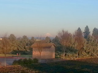 The ride started out a lot like the Hagg Lake ride-cold, dreary, foggy, damp. We shivered out of the first control at Stayton as frost covered the shady spots on the roads and decorated the adjacent fauna. But as we approached Mill City, which was our lunch stop, the clouds ran away and a brilliant sunny blue sky appeared. On the way back, we had a clear view of Mt. Hood, and even caught glimpses of Mt. Adams and Mt. St. Helens. When the Cascade volcanoes are out-you know it's a nice day! (you can see Mt Hood just above the little building in the above photo)
 I regret not taking more pictures on these rides, but my hands were constantly glove covered and handling a cell phone camera in that condition just isn't conducive to great photography. Despite the lack of photographic evidence, I loved both these 200K routes. Though they were very different, they were equally wonderful. Despite being a little chilly at times, I had an absolute ball. And the weather was really terrific compared to what it could have been. We had fog, but no rain! The first Monday back at work was tough, but it was so worth staying the extra day to get that January 200K done. I'm very grateful to the Oregon Randonnuers-especially Lynne Fitzsimmons and Ken Mattina, the ride organizers-for making this a truly special vacation.
And riding around Portland with Stephanie on New Years Day...well that was just a whole 'nother level of special.
Randonneurs USA offers awards for accomplishing various feats of randonneuring including the popular P-12 and R-12 awards. The P-12 award is for riding an approved 100-199 kilometer event in 12 consecutive months, and the R-12 award is for riding an approved 200 kilometer or longer event in 12 consecutive months.
Getting the December and January events done in Montana is very difficult given our wintery weather. Last year I went for the P-12 and got my December and January events done by riding two different 100+ kilometer rides out of Portland. For this season, I've decided to go for both the P-12 and the R-12. I got my December P-12 ride done on the 1st of December here at home one day before a big blizzard hit that has left the local roads icy for the duration. So my son Jackson and I, (wife Brenda had to stay home for work) loaded up the bike again and headed for Portland.
The goal this time was to at least get my December 200K done. I contacted fellow Randonneur extraordinaire Lynne Fitzsimmons about doing one of her rides on the last weekend of 2013. Lynne was available so we planned to meet up in Beaverton to ride the Beaverton-Hagg Lake-Carlton 200K Permanent. Lynne wrote a nice detailed report on her blog so please go there and check it out. The following is a photo story of my Oregon riding:


And riding around Portland with Stephanie on New Years Day...well that was just a whole 'nother level of special.
Tuesday, September 17, 2013
Yellowstone National Park South Loop pre-ride report

It will be cool to down-right cold at the start. Expect temperatures to be around 30-45
degrees and dress accordingly. Also, the
weather in Yellowstone is unpredictable so be prepared. Steve and I got rained on for most of the
last 13 miles. It was actually kind of
pleasant, but that’s not always going to be case.
The roads are generally very good. Most of the route has about a 3 foot wide
rideable shoulder. However most of the
stretch from Lake Village to Canyon does not have much of a shoulder so use
caution there. The shoulder between
Canyon and Norris has some big ruts and potholes just outside of Canyon, but it
gets better as you go up the hill.
Even though the park is shutting down, traffic will be
busy. Our pre-ride was on a Monday and
traffic was constant all day. The
stretch from West Thumb to Lake had the lightest traffic. Watch out for the big coach tour busses, they
didn’t seem to be interested in giving any room. Other than that, motorists were pretty
courteous. It seemed like we were passed
by the same vehicles all day as they would stop at every road side attraction
and then come by again.
My advice is to take it easy on the first leg from West
Yellowstone to Old Faithful. Other than
one hill just past Madison Junction this is a pretty easy stretch. But don’t blow yourself up, as there’s some
big climbing to come.
After Old Faithful we climb up to the Continental Divide and
cross the divide twice. The first
crossing is Craig Pass, then there’s a short descent and then more climbing to
the next divide crossing. It never gets
terribly steep (maybe 6%) but the second peak is 14 miles away and 2000 feet
higher than Old Faithful. Then it’s a
short non-technical descent to West Thumb and then gentle
rollers to the Lake Hotel. It’s about 40
miles from Old Faithful to our next control at Lake. This was by far the toughest section for
Steve and I and we needed a long break in Lake to recover. So make sure you’re well fed and hydrated out
of Old Faithful and have plenty of supplies along.
As I said, the road from Lake to Canyon doesn’t have much
for a shoulder. This is in the Hayden
Valley and there will probably be lots of bison out-and-about. The wildlife’s presence does tend to slow
down the cars and trucks. But watch out for motorists around a bison jam-the
drivers are more unpredictable than the animals.
If you’re not too tired, the section between Canyon and
Norris is fun. There’s a short steep
climb for a mile or so then the climb becomes pretty easy (if the wind is
right). Then there’s some big downs and
ups with a short 8% descent mixed in.
It’s not that long so I didn’t need my brakes. Also, traffic wasn’t too heavy here when we
rode.
The best road surface was from Norris Junction to the
finish. The shoulder is pretty wide and
rideable. But it is very busy from Norris
to Madison Junction and there were lots of tour busses.
Controls:
West Yellowstone Chamber of Commerce parking lot: You can park here all day. There are restrooms that were open for us in
the morning, but they were locked when we got back. This control will be staffed by my loyal
volunteers Brenda and Jackson.
Old Faithful: The Old Faithful complex is huge and
everything should still be open for our ride.
Steve and I went to the first available store. Take the first left after going over the
overpass and on the Old Faithful entrance road-signs are there to guide
you. If you want to see the visitor’s
center or the geyser itself keep going and follow the signs. There’s another store by the lodge and
visitor’s center. Waiting for the geyser
can take a long time depending on when it last went off. Personally I wouldn’t wait for it. After it does go off, it will be like rush
hour getting out of there for a little while.
Lake Hotel: The only thing still open at Lake will be the
dining room in the Lake Hotel. This
place is pretty fancy and it’s a sit-down type of restaurant. I’m planning on having Brenda and Jackson
meet us outside the Lake Hotel in the parking lot with some snacks and water.
Canyon Village: If
you want to actually see the canyon take the right turn on to north rim drive
(after the turn to the south rim, and the turn to the brink of the upper falls. The north rim drive will loop to Canyon
Village and it only adds a couple of kilometers). If you’ve never seen the Grand Canyon of the
Yellowstone then the side trip is worth it.
The restrooms in the Canyon Village Visitor’s Education Center should
still be open. These are super nice
facilities and they have water fountains with a spigot to fill water
bottles. The only place open to get food
in Canyon will be the Outdoor Adventure Store.
They have pop, chips, candy bars and gas station style sandwiches.
The scenery on the whole route is amazing of course. The views of Lake Yellowstone are especially
wonderful. Don’t forget to look around
now and then.
Other than bison and a few elk there wasn’t much for
wildlife when we rode, but keep your eyes open.
If bison are on the road try to keep a car between you and the
animal. The bulls are especially grumpy
this time of year as it is mating season.
It took Steve and me 10 hours and 40 minutes to complete the
ride, including two long rest stops at Lake and Canyon. We finished with plenty of daylight, but we
did turn on our blinky taillights for the last 20 or so miles just for safety
sake as it got cloudy. Steve observed
that when he turned on his taillights cars seemed to give him more room. I would recommend everybody take a taillight
and a headlight along just in case you’re delayed and it starts to get dark.
I would recommend that we let ourselves get spread out on
the road. Don’t form a long pace
line. It is Yellowstone after all. You don’t want to be staring at someone’s
back tire for 200K. Also, ride single
file and save the visiting for the rest stops.
It’s too busy to ride side-by-side and the park rangers really frown on
it. Here’s a little video about riding
in Yellowstone HERE (scroll down to the bike video).
Thursday, September 5, 2013
Double Days, Double Divides
More Photos Here Results Here


I continue to conquer new territory in Montana as a Regional
Brevet Administrator (RBA)-this time the Capitol City of Helena and the Electric City of Great
Falls-along with a big swath of country in this big state.
The Helena-Great Falls-Double Divide 600K Brevet, was
scheduled for Labor Day weekend, 2013.
At 5:30 AM 4 randonneurs, including Ronaele Foss from Colorado Springs,
Ken Billingsley from Molt, Karel Stroethoff from Missoula, and myself from
Belgrade set off over the north hills of Helena to Great Falls…and beyond.
Early on we had an 18 mile stretch on I-15, but at that time
of the morning there was almost no traffic-allowing riders to be in the travel
lane and off the debris covered shoulder for much of the way. Despite that, Ronaele got a flat, but she had
it repaired in short order.
After the I-15 section we got on a very quiet and incredibly
scenic frontage road through Wolf Creek Canyon along the Missouri River pretty
much all the way to Great Falls. This stretch
reminded me of my favorite local ride in Jefferson Canyon, but it’s much longer
and dare I say has even less traffic. We met Mike Biggle from Great Falls out on
his bike on this section. He had ridden
from Great Falls that morning in the hopes of finding us out there. We had a nice cruise and conversation back to
Great Falls. Along the way we saw plenty
of deer, a great blue heron, and even some big horn sheep by Hardy Bridge. The sheep were up on a rocky ledge above road
looking down on us. Ken and I stopped to
say hi to them, but they didn't seem to be too impressed.
After the quiet and scenic beauty of the frontage road, the
route’s personality changed dramatically as we entered Great Falls. There’s no quiet route entering Great Falls
from the south. You have to get on I-15
for a mile and go screaming along the super busy 10th Ave. South
until quieter streets become available.
I designed this route to use some of Great Falls’ river’s edge trail, a
piece of bicycle infrastructure the City is somewhat famous for, but articulating
how to navigate the trail on the cue sheet became problematic. Ken and I had no trouble, as I had pre-ridden
this part of the route with Mike 3 weeks ago, but Ronaele and Karel who were a
ways behind did get lost for a while.
Fortunately, they figured it out eventually, making it to the Walmart on
Smelter Ave. which served as a checkpoint.

We left Great Falls on a gritty frontage road to the small
town of Vaughn. Traffic was light, but
fast moving. There’s not much to look at
on this stretch except railroad tracks, stock yards, industrial buildings, and
some suburbs. At Vaughn we got on Highway
200, which is a major thoroughfare connecting Great Falls to Missoula. Traffic was heavier, but there’s 2 travel
lanes in each direction and a big wide shoulder. Unfortunately, the road was recently
chip sealed and the shoulder was especially course. Ken and I rode on the white line most of the
way and the traffic went around us in the passing lane…for the most part.
The road stayed flat all the way to Simms where we had
another checkpoint and took advantage of their little C-store to get some
refreshments. The next leg to Fairfield
is only 11 miles with a long hill in between, but on a nice quiet and smooth
road. At Fairfield, home to an Anheuser
Busch grain storage facility with the biggest grain bins I ever saw, we had
another checkpoint and set off across a meandering and low traffic road to the
small town of Augusta.
I was starting to lose my good feelings as took the back
roads to Augusta. I probably went too
hard early in the route. On the other hand
Ken, who hadn't been feeling all that well early, seemed to get a second
wind. I was having a hard time holding
on to his wheel. Augusta was a welcome
stop. They had a nice grocery store and
there was a bench across the street to sit on for a while.
Ken and I were making great time as we pressed on to our
next checkpoint at Wolf Creek. Mike and
his wife Regina came along in their truck about 25 miles from Wolf Creek to see
how we were doing. That was really nice
of them. They then headed up the road to
check on Karel and Ronaele and call Brenda to give her a status report on how
everybody was doing. On a route as
lonely and isolated as this one was, it is really a morale booster to see a friendly
face and know you're not out there totally on your own.
Ken and I met up with Brenda at the store in Wolf
Creek. We were on schedule to get into Helena around midnight, so we'd have time for a
pretty good sleep break. As per Mike and
Regina's report, Ronaele and Karel were riding close to each other, and a couple
of hours behind. They still had plenty of time in the bank as
well.
8 miles after Wolf Creek we were back on I-15 in the
dark. Ken was riding much better than
me at this point and I bid him to press on ahead. He did, and was soon out of sight. I slogged up the big hill between Wolf Creek
and Helena as best I could. The fast
descent wasn't much fun in the dark on the freeway shoulder. Traffic was light so I moved over to the travel
lane when I could and went a bit faster.
But I was still cautious and just couldn't let it go. The disc brakes on my bike did their job until I was on flatter roads. I got
into Helena just before mid-night and hit the bed at 12:30 with the alarm set
for 3:50 AM.
I woke up for day 2 feeling light headed, nauseous, and with
a weird chill. Today was going to be a
toughie. Despite the ill feelings, I met
up with Ken and Ronaele at the Town Pump on Montana Ave in Helena. Ronaele was going on 2 hours less sleep than
me, but looked like she was handling it much better.
The route for Day 2 would feature two crossings of the
Continental Divide at MacDonald Pass and Flesher Pass, both at over 6,000
feet. The route is similar to the Helena
Bicycle Club's Double Divide ride-except they break it up into two days. We on the other hand would be doing the
entire 136 mile loop in one day with 240 miles in our legs from the day before.


The MacDonald Pass climb starts right out of Helena. I felt weak and climbed very slowly. Soon Ken and Ronaele were out of sight. The morning was pleasant, if a bit chilly,
and there was very little traffic on the 4 lane highway. I got over the climb after a couple of short
rest stops. My appetite finally came
back about halfway up and I chomped down a cold McDonald's hamburger that
Brenda got me the night before. The
descent was fun. I didn't need the
brakes as I cruised down with the road all to myself.
I met up with Ronaele and Ken after Avon where Brenda and
Ronaele's husband Paul had set up a secret checkpoint. She reported that Karel had left at about 7
AM and he was a ways behind but moving well.
I wasn't too worried about Karel.
He's done so many epic rides over the years, including a 1200K earlier this summer in Alaska-he'd be fine.
Ronaele and Ken were back on their way again in short
order. I lingered awhile, taking
advantage of Brenda's hospitality. It
would be a long stretch to Lincoln and our next chance to get food and water.
The ride to the junction of Highway 200 was really nice. Traffic was fast moving but light. There was
no shoulder, but I didn't have any
trouble. I saw a big black bear out in a
hay field after Nevada Lake. A couple of
cars were pulled over watching him. I
pointed out the bear to an oncoming loaded touring cyclist.
At the junction of Highways 141 and 200 it was getting hot!
And Highway 200 was recently chip sealed and super busy. I started carefully nursing my liquids as it
was going to be a long 15 mile uphill ride to Lincoln. Fortunately, the road improved and a nice
shoulder emerged. I rolled into the
biggest C-store in Lincoln. I could see
Ronaele up the road just leaving town, and Ken was putting his helmet on and
getting ready to go as he chatted with Paul who had been keeping an eye on all
of us throughout the ride as he drove the route. I stepped inside and got a sandwich and sat
down to eat it. Outside I saw Ken was
still there and both he and Paul were working on a wheel. I saw a tube come out and knew he must have
had a flat. At least he had a nice shady
spot to fix it, and Paul's floor pump too.
But there must have been something wrong because they kept replacing
tubes and pumping it up and then taking it apart again. I went outside to see what was going on. A leaking valve on one tube and another valve
that wouldn't take air apparently. Ken
finally got his wheel on and was underway. I went back to refueling.
The turn to Flesher Pass road is only 10 miles from Lincoln, but 5 miles of that was on one of the worst
paved roads I had ever ridden. There was
no shoulder, lots of pot holes, and a lot of very fast moving and unforgiving
traffic. I got through this stretch
unscathed, but Ken later reported having to bail out to the ditch a couple of
times as the cars and trucks couldn't be bothered to move over and/or slow
down. After a bit of research I learned
that this stretch of Highway 200 is scheduled to be rebuilt in 2014. I certainly hope so.
I came across Ken at the foot of the climb to Flesher Pass,
working on his tire again. A leaky valve
would plague him all the way back to Helena.


Temperatures were well into the 90's as we climbed the
pass. Again Ken was soon out -of-sight
as I still had no energy. I walked a few
hundred feet, just to rest my legs and aching backside, but the Flesher Pass
climb, though hard, is pretty short from the pacific side and soon I was at the
top with the hope of a long sustained downhill to the finish.
Early on the descent was fun. A wind in our face kept it at a safe speed as
the road twisted and turned. But as the
incline got shallower, the fun and speed stopped.
Though we were going downhill I had to work to get 12 mph. The wind felt like a blast furnace. The miles ticked by much to slowly.
The Canyon Creek store, about 20 miles from the finish was
an oasis. I met Ken at the store as he
was going out. He was still fighting
that leaky inner tube, but kept moving.
I went into the store and downed a coke and poured a cold bottle of
water into my camel back. I had enough
fluids to get to the end...but did I have the energy?
10 miles went by-then a
few more. After a short climb and
descent I was finally back in the Helena Valley and crawling to the
finish. Brenda was at the Town Pump to
greet me. I was hot, tired and
crabby. But after loading up the bike it
began to sink in what I had accomplished.
We headed back out on the route to look for Karel, who we found soon
after just approaching the Helena city limits.
He was hot and dry as well, missing the Canyon Creek oasis as it had
closed before he went by. But Karel, who
had started 2 hours after me, only finished about 50 minutes behind me. So he had ridden very well despite spending
the entire month of August off the bike.
Ronaele had long since finished. This was her second super randonneur series
of the season. She has been putting on a ton of miles this summer and is
planning on riding 2 1200K's yet this year!
Amazing. I am in awe.
So with that, I finished my 4th super randonneur series and
my first since 2011. It feels good to
get it done. Now I have to figure out
how to do it without being such a mess at the end. I guess that will come with more experience.
Many thanks to our volunteers Brenda, Paul, Mike, and
Regina. It was a hard fought 600K-and a
route I would love to do again someday, but only after Highway 200 east of
Lincoln gets fixed and I reconfigure the route in Great Falls.
Tuesday, August 13, 2013
Helena-Great Falls-Double Divide Partial Pre-ride Report
Ride: Helena-Great Falls-Double Divide 600K Brevet. Click here for the map, profile, and navigation info.
Date: Saturday, August 31-September 1, 2013
Start Time: 5:30 AM
Registration from 5:00 AM–5:30 AM. Click here for the paperwork. Please CONTACT ME before the ride to let me know you're coming.
Start Location: Town Pump C-Store, 2900 N. Montana, Helena, MT.
Time Limit: 40 hours. Lights and reflective gear will be required. See Article 10 in the Rules for Riders.
Entry Fee: $20. No membership required, but RUSA membership ($20) is encouraged. Membership forms will be available at registration.
Motels: Lots of choices in Helena. Holiday Inn Express & Suites is near the ride start.
Mike Biggle and I pre-rode a portion of our upcoming 600K
route on Saturday August 17. We started in Wolf Creek and rode to Great Falls, then Vaughn, then Fort Shaw. I continued to Simms and then went off route on a short cut back to Wolf Creek on Highway 200 due to heat and possible T-storms.
 The only part of the route that I haven’t ridden or driven
is between Simms and the junction of Hwy 200 and US 287 south of Augusta, but
that looks pretty straight forward.
The only part of the route that I haven’t ridden or driven
is between Simms and the junction of Hwy 200 and US 287 south of Augusta, but
that looks pretty straight forward.

The ride starts at the Town Pump on North Montana Avenue
(across from Shopko) at 5:30 AM-check in is between 5 and 5:30. There’s a vacant lot just north of the Town
Pump with a City Brew coffee hut on it that looks like a good place to set up
for the ride start. There’s on-street
parking on the numerous side streets in the area if you are driving to the
start.
We head north on North Montana. The road gets narrow, but at the hour we’re
starting, traffic should be light. We
then get on I-15 for 19 miles. I-15 has
very light traffic for an interstate, and there’s a good shoulder. There was some road construction on the first
few miles, but it doesn’t look like it will be in our way. The worst part of interstate riding is the
debris on the shoulder. Flat tires are a
risk we’ll have to endure on this entire route, be prepared.
After I-15 we get on a frontage road all the way to Great
Falls. This is mostly flat, except for
some hills by Cascade and after Ulm. Traffic will be quite light. This will be one of the most pleasant parts
of the whole brevet so enjoy!
Our first checkpoint is the store/gas station in Wolf
Creek. They have all the junk food any
randonneur craves. There are also c-stores
in Cascade and Ulm.

We acquire the River’s Edge Trail, which starts out looking
like a sidewalk along River Drive.
Follow it and loop down through a tunnel under the big bridge carrying
10th Ave. South. The trail
gets a bit confusing, but all the branches of it seem to come back together,
just stay along the river and parallel to River Drive. The trail crosses River Drive a couple of
times as well so be prepared for that and watch out for cars on River Drive
when crossing. Ultimately we’ll end up
at the 9th Street Bridge.
Follow the sidewalk up and cross the bridge on the bike/ped path along
the left side of the bridge as you head towards the oil refinery on the other
side of the river. Stay on the sidewalk
after the bridge and use the crosswalk to get across Smelter Ave if traffic is
heavy, which is could be-as this is a very busy intersection in Great Falls.
Once on the north side of Smelter Avenue-head west on a good
(but again gritty) shoulder. You’ll need
to get a receipt from a business on Smelter Ave. There’s a Cenex C Store right after the 9th
Street Bridge, a Walmart Super Center (Mike suggested parking your bike inside
by the shopping carts), a Loaf and Jug C-Store, and further along a health food
store and a Sinclaire C-Store. There’s a
Taco Johns when we intersect with the NW Bypass if C-Store food doesn’t do it
for you.

Highway 200/US 89 has a great big wide shoulder and also two
lanes in each direction until Sun River.
The shoulder has new chip seal so it’s gritty. Traffic was light so Mike
and I rode left of the white line and rumble strip while traffic passed us
easily in the outside lane. A good
mirror is handy on this part of the route if you don’t want to stay on the
shoulder.
After Sun River the road narrows, but the wide shoulder
remains all the way to Simms. We have an
info control at Simms before turning north to Fairfield on the Highway
565. There is a gas station/C-Store at
Simms across the road from the intersection to the road to Fairfield.

The store in Wolf Creek closes at 9 PM. After that we’ll have someone out there for
you with some food and drink.
Then it’s back to Helena and on the same 19 miles of I-15
that we took on the way out of Helena.
The second day we go through Helena on US 12 and go over the
Continental Divide at MacDonald Pass.
I’ve never ridden it, but have driven it plenty of times. I always see lots of cyclists on this road so
I take that as a good sign. There is a
shoulder, but it will probably be gritty as well. There’s a store in Elliston on the other side
of the pass, but it doesn’t open until 8 AM so be stocked up out of Helena if
you’re going to be early. We will try to
have some support on the way to Lincoln.
There is a café in Avon-just past Elliston. Otherwise, look for a hose bib on a building
to refill you water bottles.
Lincoln has lots of services. Then it’s a climb over the Continental Divide
at Flesher Pass and a nice long descent back to Helena.
This ride will be a challenge, let’s hope we’re up for it!

Saturday, July 27, 2013
Arguing With Myself, The Bearthooth Highway 400K Brevet
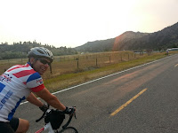
 |
| See the road way down there? |
We had five randonneurs at the 5AM start in Columbus on July 20, 2013 including fellow Montanans Ken Billingsley and Joshua Loveland, and we were joined by Mark Roehrig and Hugh Kimball of the Seattle International Randonneurs. Mark and Hugh were the first SIR members to ride one of my brevets so I was really excited. But there was trepidation also. My wife Brenda is usually available to handle the paperwork, staff a control, and provide neutral emergency support. But she was in Alabama at a family reunion-so we would be totally unsupported for the toughest brevet of the season.
The first 100K of the route going from Columbus, to Joliet, to Bridger, and Belfry was easy. Most of the route was flat and winds were light and favorable. Ken, Mark, and Hugh took advantage and rode away at a quick pace. Joshua and I, on the other hand, agreed that we needed to ride conservatively if we were to have any chance of success. This proved to be a wise decision for me later on.
When I decided on this route earlier in the year, I didn't bother to look to see what else might be going on in the area that weekend. As it turned out, this particular weekend was the Beartooth Motorcycle Rally, centered in Red Lodge. This is the biggest motorcycle rally in Montana with 10,000, mostly noisy Harleys converging on the area-all joyriding on the same roads we would be riding. This became very apparent as we began climbing the big hill between Belfry and Red Lodge. Harleys would be our constant companion until we left Red Lodge again that evening.
 |
| Harleys at the Top of the World Store |
Joshua and I got to the grocery store in Red Lodge just as we saw Mark and Hugh leaving. Ken was still at the store and we had chance to chat for minute. They looked to be doing pretty well. Joshua and I bought some food, ate, and chatted with some locals in front of the store. We knew the next phase of the ride, climbing right from Red Lodge up the Beartooth Highway was daunting. The temperatures were heating up as well.
We were both struggling, but Joshua was starting to lag behind. Before he was being conservative, but now I sensed that the ride was getting to him. I was also slow, but my legs didn't feel too bad. As we approached the first switchback, we both agreed that this route was ridiculous and we contemplated turning around. But we decided to press on to at least the Scenic Overlook rest area about 3/4's the way up. It took a few rest stops, but we finally made it to the overlook. No small feat-and a place many cyclists turnaround. Joshua had decided he was going to head back to Columbus from there. I agreed to do the same, not feeling like I had the gas to get the rest of way over the pass to the Top of World Store and then climb back over again. It just seemed too hard. But we waited a while, ate a bite, drank some fluids and thought about it. Joshua gently encouraged me to keep going. I noted that I still had plenty of time, the weather was as nice as it would ever get on the Beartooth Highway, with light breezes and no chance of thunderstorms, and my legs didn't feel all that bad. So at the last second, I bid Joshua farewell and kept heading up the mountain. Joshua would still end up with about 170 miles for the day with a lot of climbing-no small feat indeed!
I met Hugh as I was flying down the other side of the mountain and Ken and Mark as they were riding through a construction zone after the turnaround at the Top of the World Store. There was no place to chat as traffic was moving through the construction, but they appeared to be doing well.
After an hour or so at the Top of the World Store-about 10 miles from the west summit of Beartooth Pass, I began the climb back over. It was about 5PM, plenty of time to get back to Red Lodge in daylight. After a short delay at the construction zone, I rode through. The construction zone narrowed the road to one lane for about one mile and it was controlled by a traffic light and pilot cars. This meant that I would have the road all to myself for 10 to 20 minutes, then a big group of bikes and cars would go by, and then I'd be by myself again. I got into a rhythm of pulling to the on coming lane and walking when the big group over took me. I could hear the motorcycles coming for miles so I had plenty of warning. This worked really well and allowed me to save energy and have less stress. Finally over the top, I was free to fly and I was back in Red Lodge in no-time.
I took an extra long stop at the Town Pump in Red Lodge. I was plenty on time, but I wanted to wait for the sun to set, as I would be riding west for a while. I had more nice chats with bikers, many who had saw us all day as they cruised up and down the pass. They were all impressed with what we were doing.
As I left Red Lodge, I rode past the local fair grounds on the way out of town where a lot of the bikers were camping. As soon as I passed the campground, the air became silent. No more Harleys (or hardly anymore) the rest of the ride. It was so peaceful!
The first half of the 50 miles road between Red Lodge and Columbus has big, big rollers and I was slow going up. The hills were made a little tougher as it got dark and I couldn't quite see how big they were. But it was a pleasant evening, with a near full moon over my left shoulder. The 2nd half of this stretch is a nice gradual downhill and I made good time, cruising effortlessly at 20 mph for a long ways.
I got back to Columbus at mid-night and I had an out-and-back to Rapelje and 50 more miles to go. The final control closed at 8AM so I had plenty of time. I decided to go back to my motel room at the Super 8 in Columbus to change shorts, re-supply, and take a nap. This was almost a fateful decision. That bed felt soooooo good! I woke up after about an hour and a half and sat on the edge of the bed-thinking I didn't want to go out again. The road to Rapelje is one of those roads that seems to be up hill both ways. I decided 200 miles was enough-I was proud of what I had accomplished. I didn't need to finish the 400K. I had my clothes off and was about to get in the shower when I thought about Mark, Hugh, and Ken. They were still out there and they'd be wondering what happened to me. So I got dressed and prepared to leave, but hesitated. I sat on the edge of the bed again-thinking about those hills to Rapelje. I decided I definitely wasn't going. I would leave a note on Ken's car that I had abandoned and then go to bed. So the note was composed and placed. But as fate would have it, as I went back in the motel I saw Ken and Hugh at the front desk getting their brevet cards signed. They had just finished. I went over to congratulate them and tell them I was quitting. They were both sympathetic. Ken asked if I was trying for a full brevet series this season and if so was there another 400K somewhere that I use as a make for this ride. I said there wasn't and that I would not get a full series in. Ken then simply said, so at the end of this season I will be 50 miles short of a full series...I thought about that for a second and realized he was right-I'd hate myself if I quit now. Hugh and Ken assured me that the hills on the way to Rapelje were short. The ride isn't that hard. I knew they were lying, but decided to believe them anyway and headed out the door. It was sometime after 2AM.
I met Mark on the outskirts of Columbus. He only had a couple of miles to go to be finished. I congratulated him and headed out to the prairie. As I expected, the hills were tough and I was slow. I also had a light headwind. But I kept going and finally saw the lights of the tiny town of Rapelje way off in the distance. I was still 10 miles away, but the biggest hills were done for the time being. I mailed my post card at the Rapelje post office (the way we proved we were there) and had a quick snack. The silhouette of the four Rapelje grain elevators against the slowly brightening eastern horizon was really cool. The town, other than a barking dog, was totally silent.
 |
| Rapelje, Montana Sunrise |
I made may way back to Columbus slowly, walking part way up the biggest hill as day broke. I snapped a nice photo of the sunrise behind me as I walked. It really was a beautiful site. I had gone 'round the clock and then some, but I still had plenty of time. The final 10 miles was downhill, as Ken had promised, and I finished at 7:04 AM. Hugh saw me in the hall of the motel and greeted me. We both agreed it was a hard, but wonderful ride. I took a quick shower and then crashed in my bed until checkout time. I was so close to quitting on this ride-twice, but thanks to my fellow randonneurs, I didn't and I was glad. I don't know if I could do a harder 400K-I sure don't think I want to try. This one was a doozy!
Thursday, July 11, 2013
Bert Karp Memorial Populaire-A Salute to All Bike Ride Volunteers
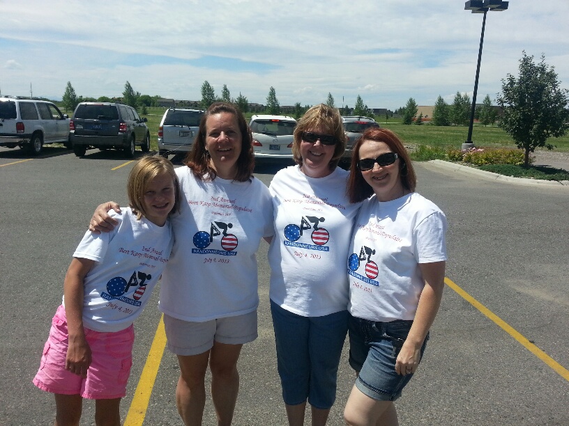 |
| Danielle, Shannon, Deborah, and Brenda sporting the 2013 volunteer's t-shirt |
Results Here.
I was in Central Montana-miles from anywhere, 33 hours into the 36 hour 600K brevet that would qualify me for Paris Brest Paris-2011. It’s been a long ride and I’m cooked. As I get around a bend in the road, a familiar tan station wagon comes into view parked at a wide spot along the road. The back hatch pops open and a lawn chair is setup. As I pull up, I’m greeted by a smiling face and the questions, “How’s it going? What do you need?”
It’s my mom at the penultimate checkpoint, patiently waiting for me-more than an hour behind the previous rider. At this point in the ride I’m tired, a little cranky, and I don’t really know what I need except to get off the bicycle for a while. Mom hands me a coke and a variety of snacks. Pretty soon I’m feeling better and ready to get back on my way.
The above scene played out numerous times over the
years. Mom happily set up out in the
middle of nowhere with a trunk full of goodies.
Or mom shuttling club riders back to the finish after a 30 mph crosswind
kicked up making it difficult and dangerous to ride. Or mom running a rest stop for our local bike
club’s century ride. When me and
eventually most of my family took up cycling, mom was always out there with us,
taking care of us, and watching out for us.
She loved it.
 |
| Mom at a checkpoint on my 2011 600K brevet |
Cancer took away our biggest fan and supporter on March 5, 2012.
I had already scheduled my first populaire as a
RUSA Regional Brevet Administrator (RBA) for the summer of 2012-so when the
family was still together after the funeral I casually mentioned the idea of
dedicating that ride to mom’s memory. That’s
all that was needed to be said, as the family were all over it. Plans were made, volunteers were rounded up, t-shirts
were printed, and the first Bert Karp Memorial Populaire was held on July 28,
2012.
Thirteen riders started and finished that first edition-a modest number, but more than twice as many as any of my previous
randonneuring rides that I had hosted.
We were joined by experience randonneurs, local riders, and several
family members including my sister Jody and her two boys 18 year old Brian and 14
year old Tyler and my brother Travis who flew to Montana with his bike from
Savannah, Georgia for the ride. The rest
of the family, including spouses, grand kids, and in-laws provided excellent
support at 3 checkpoints. It was a fun
emotional day, and one we wanted to try again.
 |
| The 2012 t-shirt design |
The out-and-back 109K (68 miles) route, which was the same as 2012, rolls across the floor of the Gallatin Valley in Southwest Montana from Bozeman to Three Forks and back. The course is mostly downhill on the outbound leg, which gets everybody committed, and then a gradual uphill drag on the way back as the heat of the day catches up to add to the challenge.
The 2013 edition saw 21 riders start and 21 riders
finish, including 5 of my nephews ranging in age from 12 to 19. Everyone
finished with more than hour to spare.
It was an emotional moment watching the riders come in sweaty, and
exhausted, and proud of earning that little populaire pin. I couldn't help
but have the feeling that mom was still with us, watching over us, and loving
every minute of it. A big thank you to
all those who came out to ride and for riding so well. The list of riders and their results are
posted here. And there's lots of photos posted here.
A special thank you goes out to all the volunteers
who helped out. First and foremost my
wife Brenda, who has been there with me since I've become an RBA and has
really stepped up in the absence of my mom.
Also, a big thanks to my son Jackson.
Jackson is not a long distance cyclist, but he has proven to be a
capable checkpoint staffer. And the rest
of the crew: Shannon Karp, Danielle Karp, Rick Schmidt, Deborah Karp, Jameson
Karp, LaVerna Schmidt, Deb Korrison, Chris Stucky and her dad Neville, and my
dad and mom in-law Billy and Mindy Horne. Your service to our ride was
appreciated so much.
Not only is the Bert Karp Memorial Populaire a
tribute to my mom, who loved to take care of people, it is a tribute to all
bike ride volunteers. To those people
who handle logistics, paperwork, refreshments, watch over the route, wait for
us at rest stops, take pictures, cheer us into the finish line, along with
everything else…We Salute You! Thanks
for all you do.
.jpg)
.jpg)
Subscribe to:
Comments (Atom)
