Ride: Helena-Great Falls-Double Divide 600K Brevet. Click here for the map, profile, and navigation info.
Date: Saturday, August 31-September 1, 2013
Start Time: 5:30 AM
Registration from 5:00 AM–5:30 AM. Click here for the paperwork. Please CONTACT ME before the ride to let me know you're coming.
Start Location: Town Pump C-Store, 2900 N. Montana, Helena, MT.
Time Limit: 40 hours. Lights and reflective gear will be required. See Article 10 in the Rules for Riders.
Entry Fee: $20. No membership required, but RUSA membership ($20) is encouraged. Membership forms will be available at registration.
Motels: Lots of choices in Helena. Holiday Inn Express & Suites is near the ride start.
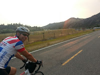
Mike Biggle and I pre-rode a portion of our upcoming 600K
route on Saturday August 17. We started in Wolf Creek and rode to Great Falls, then Vaughn, then Fort Shaw. I continued to Simms and then went off route on a short cut back to Wolf Creek on Highway 200 due to heat and possible T-storms.
 The only part of the route that I haven’t ridden or driven
is between Simms and the junction of Hwy 200 and US 287 south of Augusta, but
that looks pretty straight forward.
The only part of the route that I haven’t ridden or driven
is between Simms and the junction of Hwy 200 and US 287 south of Augusta, but
that looks pretty straight forward.

The ride starts at the Town Pump on North Montana Avenue
(across from Shopko) at 5:30 AM-check in is between 5 and 5:30. There’s a vacant lot just north of the Town
Pump with a City Brew coffee hut on it that looks like a good place to set up
for the ride start. There’s on-street
parking on the numerous side streets in the area if you are driving to the
start.
We head north on North Montana. The road gets narrow, but at the hour we’re
starting, traffic should be light. We
then get on I-15 for 19 miles. I-15 has
very light traffic for an interstate, and there’s a good shoulder. There was some road construction on the first
few miles, but it doesn’t look like it will be in our way. The worst part of interstate riding is the
debris on the shoulder. Flat tires are a
risk we’ll have to endure on this entire route, be prepared.
After I-15 we get on a frontage road all the way to Great
Falls. This is mostly flat, except for
some hills by Cascade and after Ulm. Traffic will be quite light. This will be one of the most pleasant parts
of the whole brevet so enjoy!
Our first checkpoint is the store/gas station in Wolf
Creek. They have all the junk food any
randonneur craves. There are also c-stores
in Cascade and Ulm.

We acquire the River’s Edge Trail, which starts out looking
like a sidewalk along River Drive.
Follow it and loop down through a tunnel under the big bridge carrying
10th Ave. South. The trail
gets a bit confusing, but all the branches of it seem to come back together,
just stay along the river and parallel to River Drive. The trail crosses River Drive a couple of
times as well so be prepared for that and watch out for cars on River Drive
when crossing. Ultimately we’ll end up
at the 9th Street Bridge.
Follow the sidewalk up and cross the bridge on the bike/ped path along
the left side of the bridge as you head towards the oil refinery on the other
side of the river. Stay on the sidewalk
after the bridge and use the crosswalk to get across Smelter Ave if traffic is
heavy, which is could be-as this is a very busy intersection in Great Falls.
Once on the north side of Smelter Avenue-head west on a good
(but again gritty) shoulder. You’ll need
to get a receipt from a business on Smelter Ave. There’s a Cenex C Store right after the 9th
Street Bridge, a Walmart Super Center (Mike suggested parking your bike inside
by the shopping carts), a Loaf and Jug C-Store, and further along a health food
store and a Sinclaire C-Store. There’s a
Taco Johns when we intersect with the NW Bypass if C-Store food doesn’t do it
for you.

Highway 200/US 89 has a great big wide shoulder and also two
lanes in each direction until Sun River.
The shoulder has new chip seal so it’s gritty. Traffic was light so Mike
and I rode left of the white line and rumble strip while traffic passed us
easily in the outside lane. A good
mirror is handy on this part of the route if you don’t want to stay on the
shoulder.
After Sun River the road narrows, but the wide shoulder
remains all the way to Simms. We have an
info control at Simms before turning north to Fairfield on the Highway
565. There is a gas station/C-Store at
Simms across the road from the intersection to the road to Fairfield.

The store in Wolf Creek closes at 9 PM. After that we’ll have someone out there for
you with some food and drink.
Then it’s back to Helena and on the same 19 miles of I-15
that we took on the way out of Helena.
The second day we go through Helena on US 12 and go over the
Continental Divide at MacDonald Pass.
I’ve never ridden it, but have driven it plenty of times. I always see lots of cyclists on this road so
I take that as a good sign. There is a
shoulder, but it will probably be gritty as well. There’s a store in Elliston on the other side
of the pass, but it doesn’t open until 8 AM so be stocked up out of Helena if
you’re going to be early. We will try to
have some support on the way to Lincoln.
There is a café in Avon-just past Elliston. Otherwise, look for a hose bib on a building
to refill you water bottles.
Lincoln has lots of services. Then it’s a climb over the Continental Divide
at Flesher Pass and a nice long descent back to Helena.
This ride will be a challenge, let’s hope we’re up for it!

