
London-Edinburgh-London or LEL, as it is often referred, is a 1441 Km (895 miles) Grand Randonee in Great Britain. Like PBP it takes place every four years. It is different from PBP in that it is significantly longer (by over 200K), it has a time limit of 117 hours and 5 minutes as opposed to 90 hours for PBP, and not as large in ridership (1500 on LEL as opposed to almost 6,000 for PBP). Like PBP, LEL promised a hilly route with one significantly long climb called Yad Moss. The weather, as I would come to learn, is always a mixed bag in England and Scotland. It could be hot and dry, windy, or very cold and wet. The organizers advised bringing clothing for every type of weather.
My son Jackson, wife Brenda, and I arrived at Heathrow Airport in London on Thursday morning, July 27, 2017. We were shortly joined by Brenda's parents Billy and Mindy Horne who arrived via Las Vegas after visiting relatives there. We rented a house in Erith through Airbnb-about 20 miles from the start, but with good access via public transportation.
Really liking how a late afternoon start worked for me for PBP-2015, I signed up to start LEL at 3:30 PM on Sunday. I was assigned number KK2. The start agreed with my body clock which was still partially on Montana time. The plan, for fellow Montana randonneur Karel Stroethoff and me was to ride through the first night and the next day before taking our first sleep break. Our other Montanan, Ken Billingsley who is very much a morning person, was signed up for the 10 AM start.
 |
| Me and the family at the LEL start in Loughton |
As per usual with these rides, lots of nervous energy had built up and we took off going way too fast on the hilly terrain. With my heart about to leap out of my chest, I was trying to stick with Karel (who has a GPS) when a bump sent my water bottle flying. I had to back track to retrieve it and lost the group. Fortunately, another group came along and I was able to follow and not worry about navigation for the time being. Not long after the rains came down quite heavily and I witnessed two crashes. One looked serious. After I finally caught back up to Karel, my front tire started going soft. A small sharp rock had gotten through. I got the tube changed and rejoined Karel at the first control in St. Ives-100K done.
Karel and I rode together through the night. Both of us were feeling good and with a pretty nice tailwind, we were flying. We passed many riders on that first night and found the controls at Spalding and Louth quite busy. Louth was almost out of food and we had to make do with croissants and coffee. As Monday broke, we approached the Humber Bridge, which is the 8th longest suspension bridge of its type in the world. Obligatory photos were taken on the windy bike path attached to the side of the bridge. My cue sheet somehow blew out of my front bag, but fortunately, I had packed a back-up, which I made more secure. Karel left the bridge ahead of me and I lost track of him. Now I was alone and trying to navigate on my own. My solution was to follow another rider, even though that rider was going quite a bit slower than I could go. Better to be slow than lost. After the Humber Bridge the route gets on a scary busy road for a while. Traffic was fast moving and some were probably annoyed by having to pass so many cyclists. The roads on most of the route were very narrow and required cars and trucks (or lorries as they say in the UK) to wait behind a cyclist until the on coming lane was clear to pass. If there was a blind hill or curve they just had to wait. When there was an opening, drivers would pass very quickly and sometimes very closely. Still, I found British drivers to be far more courteous than in the USA.
 |
| Karel Stroethoff at Humber Bridge |
The route gets seriously hilly between Pocklington and Thirsk, with a ride past The Castle Howard and a couple of large monuments. The route also goes along some very small roads, some no bigger than what a bike path would be in the USA. Fortunately, these tiny roads also had very little traffic. I'm a heavier rider and a slow climber with a heavy bike, so I started to lose touch with the groups Karel and I had been riding with. I could catch back up on the long downhills, but would lose touch again going up. There were however, a lot of riders out on this segment so navigation wasn't an issue until I got into the town of Thirsk. There I missed a turn and ended up riding through the town and missing the control. After some inquiries, I back tracked to the control and found Karel inside having a meal. At this point it was clear to me that Karel was going faster than me. I was also conscious of the fact that I was burning too many matches to keep up with him. I felt like I needed to take a sleep break at the next control at Barnard Castle, while Karel wanted to get the big climb up Yad Moss out of the way before stopping. I had a drop bag in Thirsk, so I cleaned up, changed clothes, and made my way out in the afternoon on my own.
 |
| A monument near the Castle Howard |
 |
| Barnard Castle school |
The sleep break did some good. I felt like I was riding strong as I passed several going up hill out of Barnard Castle, with more taillights on the horizon to show the way. This segment of the route contains the ride's biggest climb, called Yad Moss. The cue sheet said the climb was 14km long, but when did it start? We had been climbing most of the way from Barnard Castle. We passed through what looked like a forested area with a river flowing along the ride and a lot of camping and tourist sites. A light misty rain started to fall as the terrain opened up and I knew I was finally going up Yad Moss. The only sound other than my breathing were sheep bleating along the road-hundreds, if not thousands of sheep. For a long time I was alone, but as I got nearer to the top, I started to see several tail lights ahead and few bright headlights coming up behind. Even closer to the top, the light misty rain got harder, along with a gusty cross wind. Day was breaking as I finally reached the summit and I was also meeting many of the fast riders returning from Edinburgh.
 |
| Sheep and a rock wall. Lots of both in the region |
We entered Scotland shortly after Brampton. It still rained off and on, but the weather warmed considerably even as the winds became much more variable and difficult. Scottish roads proved to be very rough. I was very glad to reach the control in Moffat which was very nice with good food-even though I didn't dare try the haggis.

After Moffat there was a very long climb up the Devil's Beef Tub-a big hill outside of Moffat. Don't ask me what Devil's Beef Tub means. Then a long downhill before a lumpy finish into Edinburgh. This would have been one of best stretches of the route, if the not for torrential rains and rush hour traffic. I'm not sure I could have been wetter riding in a full swimming pool. Fortunately, I was with a large group of riders so there was no worries about navigating. Stopping was another matter. My wet rims didn't adhere to the my brake pads all that well. I had to take it really easy going down hill for fear of shooting through an intersection. A bike path on an old railroad grade was a welcome respite from the traffic and the rain slowed as we rolled into the control in Edinburgh-the half-way point of the ride. Brenda and Jackson were there to greet me, having taken the train up from London that morning. It was a real boost seeing them.
 |
| Brenda and Jackson met me at the Edinburgh control |
It was dark going out of Edinburgh and navigation by cue sheet was nearly impossible. The roads are typically not marked with a road name or highway number sign. The cue sheet called out the directional signs to the next town, but often, I just couldn't find the signs, which were usually small and hard to read-especially in a sleep deprived state. Fortunately, I was caught by a group of four Brazilians, a couple of whom spoke English. We were joined by an Italian and a couple of Englishmen. This little group of United Nations made their way up some steep and tiny narrow roads above Edinburgh. As per usual, our little group broke up. Me and an English guy climbed faster than the rest of the group, but on the descent the same English fellow went very cautiously while the group from Brazil disappeared out of site. I should have gone with them but waited too long. The result was I was somewhere in between and alone on the dark descent to Innerleithen. I finally saw some tail lights going into the town and then picked up up the arrows the organizers set out to mark the last few turns. Inside the control I got to briefly meet the people I had been riding with.
The rider from Italy asked to go out with me on the leg to Eskdalemuir. He was having trouble with is GPS and he wanted to go with me and my cue sheet. Kind of a turn of the tables there. My Italian friend, (I can't recall his name) was very cold and took a long time get back to his bike, but I waited for him and we set off into the night. Fortunately, this leg was pretty easy to navigate. It included three long climbs so progress was slow. When my Italian friend fell behind, I waited after the first descent where he came in shivering despite being covered head to toe. The cold was having a harsh effect on riders from warmer climates. There were only a couple of cues the rest of the way so I gave him the directions and pressed on. He made it safely to Eskdalemuir and he thanked me for the help. I think he got his GPS working again.
I was really sleepy in the early morning hours so I took a half hour nap in Eskdalemuir and then headed back out into more hilly roads and off and on rain. I was beginning to question the wisdom of paying all this money to come to the UK to be miserable. I just wanted this thing to be over. But there was a long ways to go.
Now back in England, Brampton was a good stop for me both directions. I got something to eat and took a 15 minute nap in the rider lounge area. I was looking forward to the Yad Moss climb in full daylight. The sun was out and I was hoping to get some pictures. The ride to Alston and the foot of the climb was up and down, but trended up and very steep at times. On one hill I got off the bike and walked after another rider nearby had tipped over after stalling out. Much to my dismay, I could see the big hill in front of us shrouded in mist and knew we were going to get wet again.

The steepest part of the the Yad Moss climb is right in Alston on cobblestones. I didn't even try-I just walked it. The wind was blowing hard and a misty rain was hitting me sideways. As I started out, I noted several riders returning to Alston-either to wait out the rain or to abandon. I later learned that a lot of riders abandoned at this time as the conditions were really rough. Despite the misery, I was not alone. Several riders were heading up the big hill. The grade is not steep but the climb just goes on forever. It rained harder and harder and crosswinds picked so no pictures. Finally at the top, the descent was still a grind as the wind was blowing right in our faces. Not only was this hard, but my average speed was very slow and I was not replenishing the time lost resting in the controls.
For some reason the organizers had us take a slightly different route back to Barnard Castle. So instead of a long down hill like I was expecting it was more up and down, with a lot of steep punchy climbs. I was really starting to lose it mentally here. I was angry with the weather and the route designers who seemed to want to take us over every paved goat path in the area-the steeper the better.
 |
| Castle ruins at Barnard Castle |
After a visit to my drop bag and a shower, I signed in for another half hour nap. The volunteers said I had an hour and half in hand coming into Thirsk and I was in good shape as the route gets flatter and faster later on. I took their word for it and indulged in the nap-which I probably couldn't have done without anyway. Thirsk to Poklington went pretty well. It had stopped raining for the moment so I could read my cue sheet and the roads seemed somewhat familiar. It was still hilly and one ascent in the dark caught me in the wrong gear forcing me to dismount and walk. Later I had to take a 10 minute road side nap against a utility box while also waiting for a few more riders to come along. Daylight was on as we went past The Castle Howard again and I followed another rider through a forested area with a tree canopy completely covering the road. It was beautiful and tranquil moment with the birds singing.
I took a 15 minute nap on the floor of the cafeteria in Pocklington where they were playing a drive time radio station over the loud speakers with some great 80's music. Drive time radio with an English accent was interesting to me for some reason.
Out of Pocklington a group of guys made up mostly of English guys caught me and offered to include me in their paceline. I had been seeing these guys off and on the whole way so we were starting to get to know each other. Unfortunately, I didn't get everyone's name but I believe there was a Peter, Gerrard, Mike and a couple more (sorry guys, but I'm terrible with names even when I'm not sleep deprived). My French friend was with us for a while as well, but then later disappeared. Everyone knew my name because it was on my RUSA tag on my carradice bag. We worked together as best we could, but it was hard to maintain a paceline with everyone being so tired and the terrain being so hilly. It was nice to have some help with the headwind, which was growing ever stronger.
After getting rained on hard again a couple of times and peeling rain gear on and off, we crossed back over the Humber Bridge and bought some snacks at a small grocery store. A local came up to find out why he was seeing so many bikes coming though town. We were happy to present the gospel of LEL and he was impressed and gave us lots of encouragement.
After the Humber Bridge the route goes through a region called the Lincolnshire Wolds. It was an easy section going out with a tailwind and fresh legs, but going back it was a constant up hill head wind grind. It also rained hard some more before getting warmer and more humid. I had mistakenly thought this leg was 87 km, but when we came across a sign that said the next control in Louth was still 10 miles I almost cried. More wind, more hills, and then finally a very empty Louth-but this time with plenty of food.
Our group set off again after the Louth Control. It was warm for the first time on the whole ride. Bare arms and legs. Low on energy, I lost our group on the first big hill out of town and absentmindedly not paying attention to my cue sheet, found myself quite lost with no other riders in site in front or behind. I had some time in hand at this point, but it was all quickly evaporating as I started a mild panic. I pulled out my cell phone as I had downloaded the route into it, but in my weak mental state I could not make it work. I brought up my location on the screen and it didn't show any roads anywhere. I back tracked and found a woman walking her dog. I asked if she had seen any cyclists come by and she said no, but she saw a lot on the next road over. So I headed that way and asked a man out a walk how to go. I showed him my cue sheet and he immediately recognized Horncastle as the next town and sent me the right way (I love the name Horncastle-it sounds so medieval). Relief washed over me when I rolled up on my friend Ton. I told him I got lost again and asked to ride his wheel for a while. Ton was glad to help and off we went. It's amazing, with the fear of being lost, I had forgotten how tired and sore I was and found some new energy somewhere. Ton and I flew along, passing several riders. The headwinds were fierce and as Ton slowed I took over pulling for a short while. The effort took its toll. On a long flat stretch I lost Ton's wheel and was on my own, but only briefly. I came across the same guys I had left Louth with. They were just getting going after a break. It was such a relief that I had not lost any time, but I would pay for the extra stress.
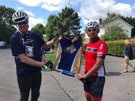 |
| I presented Ton with my Bobcat jersey in gratitude for saving my ride |
I woke up on my own about 40 minutes later. The overworked volunteers were just as tired as the riders at this point. The extra 10 minutes was needed, but my group was gone and I was on my own again. I couldn't figure out how to get out of St. Ives. There were no street name signs and very few cyclists coming out the control. Finally I saw some tail lights and headed their direction. The first several miles out of St Ives were on a wonderful flat and straight path. I could follow tail lights the whole way. When the path ended we were coming into the big city of Cambridge. I came up on an English rider who said he lived in the area. I asked if it was okay to ride along for a while. I'm sorry I don't recall his name, but he was very nice, and he got me all the way through the City which would have been tough to do on my own. After Cambridge, the dozies took over again and I had to let my English friend go as I sought rest on a bench. I set my alarm for a 10 minute snooze. It worked. I felt better and I rode on. A few miles later-lost in my own mental fog-I missed a turn and climbed a big hill unnecessarily. I got back on track okay, but I was losing a lot time on these little lost excursions.
By some miracle, I found the penultimate control at Great Easton. I still had 25 minutes in hand and only 48 km or about 30 miles to go. If could average a little more than 12 km per hour (only 7.4 mph) and not get lost I'd make the finish easily. After a quick snack I was off. Great Easton is very near London's Stansted Airport. There were lots of airplanes flying overhead. The big jets offered a bit of a distraction as I grinded over the narrow, hilly roads. It was also confirmation that we were getting close to London. Navigation started off well. The turns would all supposedly be marked so I shouldn't have any problems, despite there not being very many riders left. But panic set in once again as the arrows seemed to stop showing up and nothing made sense on the cue sheet. After going down a big hill and coming out on a very busy highway that I knew we weren't riding on, I realized I was lost again. I really just about checked out mentally at this point. I knew I was only 10 or 15 miles from Loughton and I had well over an hour left on the clock, but I had no idea where I was. I called Brenda and told her in a blubbering diatribe that I was lost and probably wouldn't make it. She immediately set to work to figure out my location generated by my Spot Tracker and determined that I really wasn't too far off course. Talking to Brenda calmed me down enough to realize all I needed to do was turn around and go back to where I knew I was on route and try again. There was still time. As I climbed back up the hill I came across two men on a recreational ride. I asked them if they knew how to get to Loughton. They didn't know, but offered that there was an orange arrow on a sign just at the bottom of the hill on the road that I should have gone down. This was a huge relief and sure enough the arrow was there. I was back on route and shortly came across a German woman looking at her phone. I asked if she was lost too. Cool as you like, she said her GPS was working fine she was just returning an email as she had plenty of time to finish. I asked if it was okay to follow her-allowing that if she was faster to not worry about dropping me. Another British man came along and we stayed together all the way to Loughton with no more drama.
 |
| Montanans Karel Stroethoff, Jason Karp, and Ken Billingsley successfully finished LEL 2017 |
Never have I been so glad to finish a ride-a ride that I am sure will be the hardest I ever attempt. Many thanks to all the volunteers and staff for LEL. The people taking care of us and watching out for us were so wonderful. The controls were excellent, the food was just right, the drop bags system, the card system-everything worked so well. Thank you to everyone!
 |
| Catching some z's at the finish-waiting for off peak hours to haul the bike home on the Tube |
